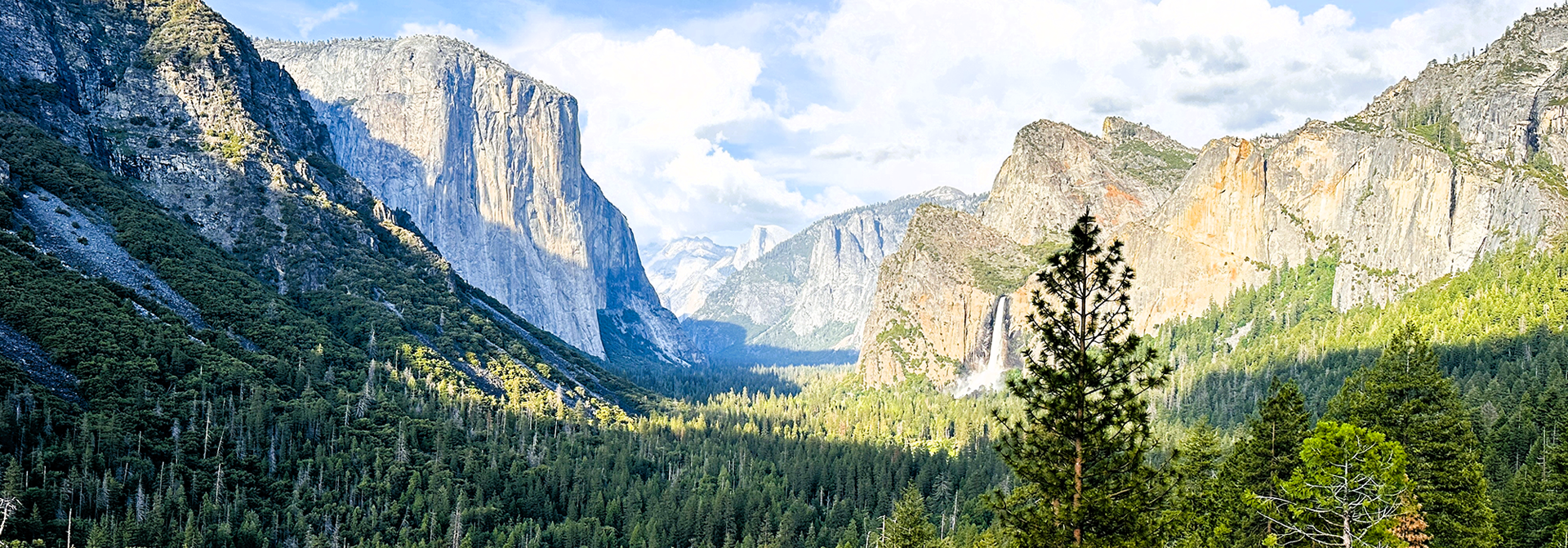
Yosemite Planet - Yosemite Valley
Yosemite Valley Hikes - MAP LINK
From Yosemite Valley, you can hike to Bridalveil Fall, Mirror Lake, El Capitan, Half Dome (permit required), Glacier Point, Yosemite Falls, Vernal and Nevada Falls. If you visit in the spring, then Mirror Lake is a must when the tall granite walls and Half Dome reflect in the lake creating a mirror like image. For a complete view of what the Valley offers, then the easy Valley Floor Loop is for you! Many trails in the Valley begin climbing from 4,000 feet to over 7,000 feet. Many of the areas along the rim of the valley are day-use-hiking areas only. Overnight hikers must obtain a wilderness permit before they begin hiking.
If you don't have time for a hike and/or if you have small children with you: Visit the Welcome Center, Ansel Adam's Photo Gallery, Happy Isles Nature Center, check out the Yosemite Museum, see the Yosemite Exploration Center and Theater, or you can take a Valley Floor Tour. Visit the NPS Website for more information on the FLOOR VALLEY TOUR
Easy Hikes
Bridalveil Fall - 0.5 miles/0.8 km round-trip; 20 minutes. Begin at the Bridalveil Fall parking area A paved trail leads from the Bridalveil Fall parking area to the base of this waterfall, which flows year round. Expect lots of water spray in spring and early summer.
Lower Yosemite Fall - 1.1 miles/1.7 km loop trail; 30 minutes. Begin at the Lower Yosemite Fall Trailhead (shuttle stop #6) This short, easy walk rewards visitors with spectacular views of Upper and Lower Yosemite Falls. This waterfall may be dry in late summer and early fall. Expect lots of spray in spring and early summer.
Cook’s Meadow Loop - 1 mile/1.6 km; 30 minutes. Begin at shuttle stop #5 or #9 (Visitor Center) Add on this short walk to your Lower Yosemite Fall hike. You'll see stunning views of Half Dome, Glacier Point, and the Royal Arches. From the shuttle bus stop at the Visitor Center (stop #5/#9), walk west along the bike path (in the direction of Yosemite Falls). At shuttle bus stop #6, cross the street and follow the path. At the Sentinel Bridge parking area, walk out onto the bridge to enjoy a classic view of Half Dome (photographed by Ansel Adams). Follow the boardwalk back across the meadow, cross the street, and turn right if you want to return to the Visitor Center (stop #5).
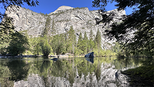
Mirror Lake/Meadow - 2 miles/3.2 km round-trip to lake; 1 hour. 5 miles/8 km loop around the lake; 2 hours (Full loop is moderately difficult; flat and long.) Begin at Mirror Lake Trailhead (shuttle stop #17). From the shuttle stop, a paved trail leads directly to Mirror Lake. Hikers may access a loop trail from the paved path. This loop follows Tenaya Creek beyond the lake, crosses two bridges beyond the Snow Creek intersection and returns past Mirror Lake. When filled in winter and spring, the lake offers beautiful reflections of surrounding cliffs. This is a great place to see wildlife.
Moderate Hikes
Valley Floor Loop Full loop: 13 miles/20.9 km; 5 to 7 hours. Half loop: 6.5 miles/10.5 km; 2.5 to 3.5 hours. Easy to moderate. Begin at the Lower Yosemite Fall Trailhead (shuttle stop #6). This trail follows many of the Valley’s first east-west trails and wagon roads. The half-loop trail crosses the Valley on El Capitan Bridge. Continue on to Bridalveil Fall for the full loop. The Valley Floor Loop provides solitude with occasional route-finding difficulty. Hike through meadows, forests, and along the Merced River. Along the way, enjoy striking views of Sentinel Rock, Cathedral Rocks, Bridalveil Fall, El Capitan, Three Brothers, and Yosemite Falls. Bikes not permitted on the Valley Floor Loop.
Mirror Lake/Meadow - 5 miles/8 km loop around the lake; 2 hours (Full loop is moderately difficult; flat and long.) Begin at Mirror Lake Trailhead (shuttle stop #17). From the shuttle stop, a paved trail leads directly to Mirror Lake. Hikers may access a loop trail from the paved path. This loop follows Tenaya Creek beyond the lake, crosses two bridges beyond the Snow Creek intersection and returns past Mirror Lake. When filled in winter and spring, the lake offers beautiful reflections of surrounding cliffs. This is a great place to see wildlife. Exhibits detail the story of the area’s lake-to-meadow succession.
Strenuous
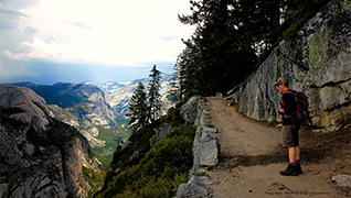
Four Mile Trail - 9.6 miles/15.5 km round-trip. 6 to 8 hours; 3,200 ft/975 m elevation gain. Begin at the Four Mile Trailhead along Southside Drive in Yosemite Valley. In summer months, take the El Capitan Shuttle to the trailhead. Trail can also be accessed from year-round Valley Visitor Shuttle Stop #7, adding about ½ mile to the total distance. This trail begins near the base of Sentinel Rock and climbs to the top of Glacier Point.
Panorama Trail 8.5 miles/13.7 km one-way to Valley floor (via Mist Trail); 6 hours for 3,200 ft/975m descent. Begin at the Panorama Trailhead at Glacier Point. As its name implies, this trail offers some incredible panoramic views of Yosemite Valley. The trail crosses Illilouette Fall after 2 miles (3.2 km) and continues partially uphill along the Panorama Cliff. At the top of Nevada Fall, the trail joins the Mist and John Muir Trails to Happy Isles.
Upper Yosemite Fall 7.2 miles/11.6 km round-trip; 6 to 8 hours; 2,700 ft/823 m elevation gain. Begin at the Upper Yosemite Fall Trailhead, Camp 4 (shuttle stop #7). One of Yosemite oldest historic trails (built 1873 to 1877), the Upper Yosemite Fall trail leads to the top of North America’s tallest waterfall 2,425 feet (739 m) above the Valley floor. Do not stray off the marked path, as you will find steep drops adjacent to the trail. Enjoy spectacular views from Columbia Rock located one mile (and dozens of switchbacks) from the trailhead.
Vernal and Nevada Falls Vernal Fall footbridge: 1.6 miles/2.6 km round-trip;1.5 hours with 400 ft./122 m elevation gain Vernal Fall: 2.4 miles/3.9km round-trip; 3 hours with 1,000 ft./366 m. elevation gain (via Mist Trail) Nevada Fall: 5.4 miles/8.7km round-trip; 5 to 6 hours with 2,000 ft./610 m. elevation gain (via Mist Trail). Begin at Happy Isles (shuttle stop #16) . An excellent view of Vernal Fall is visible from the footbridge at 0.75 miles (1.3 km). Prepare for slippery footing and a tremendous amount of waterfall spray in spring and early summer. The top of Nevada Fall may be reached by continuing 1.3 miles (2.1 km) along the Mist Trail.
HALF DOME - A PERMIT IS REQUIRED! The cables are typically up from late May to early October.
This is a 15-16 mile round-trip (out and back) extremely strenuous hike where you will climb over 4,800 ft./1,463 m. in elevation. Begin at Happy Isles (shuttle stop #16)
The trailhead is the Mist Trail or John Muir Trail to Nevada Fall. Continue on the trail, following the signs to Half Dome. The last 900 feet (275 m) of trail is a very steep climb up the east side of Half Dome. Cables assist hikers on the final 400 feet (122 m). They consist of two steel cables, about 3 feet apart and suspended at arm’s height from pipes set in the rock. The top of Half Dome is a fairly large and level open surface. Camping is not permitted on top of Half Dome.